


Antique Woburn Massachusetts Atlas Map Plate 7
 Print tear sheet
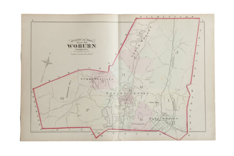
:: Antique G.M. Hopkins & Co. 1875 outline and index map of Woburn, M.A. (Plate 7). Marked on the map are North Woburn, East Woburn, Woburn Center, and Cummingsville. Also included are the surrounding areas named alongside the corresponding border of the town, which includes Stoneham, Reading, Wilmington, Burlington, and Lexington. Also of note are Horn Pond, Whispering Hill, Pine Hill, Mill Brook, and the Boston Lowell and Nashua Rail Road. Approximate size measures 17" x 26".
Item ID: 5587
-


- // This item is likely on our showroom floor in Katonah, NY, and may be subject to availability. Contact us in advance! //

Wall art, maps and charts - One of a kind accent & décor pieces, or great subject art for eclectic gallery walls.


-
![]()
Kindly see our full return policy here
![]()
Unless we have been contacted prior to purchase with questions or concerns relating to return, buyer will be responsible for original shipping at cost + return shipping. Custom items, artwork or items made from paper or wood are not returnable. Rugs have a firm 3 day return policy which is specified by drop off tracking and tracking back to us. Sunday is the only exempt day for shipping policies. Kindly also see details and terms in our return section. Due to the nature of international shipments, all sales outside of the contiguous USA are all sales final and free shipping may be limited in insurance amount, delivery method and in some cases to the nearest metropolitan area. Kindly contact prior to purchase for any and all questions.
-
![]()
-
![]()


